
Surveying has long been a cornerstone of construction, land development, and engineering. For years, traditional tools like manual total stations, levels, and theodolites were the go-to equipment for surveyors. These instruments offered precision and reliability but came with limitations, particularly in terms of speed and efficiency. In recent years, GPS and GNSS (Global Navigation Satellite System) technologies, including RTK (Real-Time Kinematic) GPS systems, have transformed the landscape of surveying.
At Benchmark, we’ve helped surveyors all across North America transition from conventional tools to state-of-the-art GPS/GNSS equipment. For those who are still considering the switch, this article delves into the advantages of RTK GPS, compares it to traditional survey methods, and highlights how surveyors like Jim have successfully made the leap.
Traditional Surveying Methods: Trusted but Time-Consuming
RTK GPS: A Game-Changing Technology
Making the Transition: Jim’s Story
Comparing RTK GPS and Traditional Methods
Overcoming Challenges in Transitioning to GPS
Benchmark: Your Partner in GPS Transition
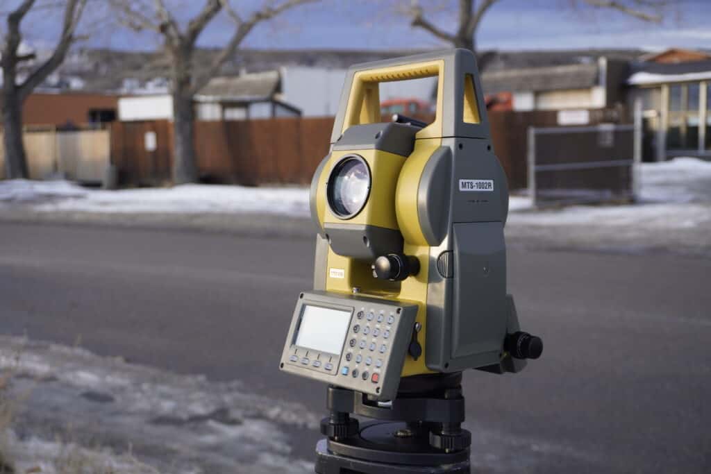
Traditional surveying relies on tools that have stood the test of time. Instruments such as manual total stations and levels are staples of the profession. I am sure most of you have had the pleasure of using them through school or as the main instrument in your toolbox. These (overwhelmingly optical) instruments are particularly effective for measuring angles and distances, performing boundary surveys, and setting out points for construction. They are widely regarded for their precision and reliability, especially in experienced hands.
Despite their strengths, traditional surveying methods are not without their drawbacks. Setting up a total station or leveling equipment can be time-consuming, particularly on large or complex sites. Moreover, these methods often require multiple personnel, with one operator handling the instrument while another sets targets or collects measurements. Environmental factors, such as uneven terrain, dense vegetation, or urban structures, can also interfere with line-of-sight measurements, further complicating the process. Traversing through rough terrain, and cutting sight lines can dramatically slow down surveys.
RTK GPS systems have brought a revolutionary shift to the surveying profession. Unlike traditional methods, RTK GPS uses satellite data to provide real-time corrections, enabling centimeter-level accuracy in positioning. By integrating satellite signals with a base station and a rover unit, surveyors can achieve precise results quickly and efficiently.
One of the most significant advantages of RTK GPS is the speed it offers. Surveying tasks that might take hours with traditional methods can often be completed in minutes. Additionally, the technology simplifies workflows, reducing the need for manual calculations and enabling a single operator to manage tasks independently. RTK GPS is also incredibly versatile, excelling in a variety of applications, from boundary surveys and topographic mapping to construction staking and infrastructure monitoring.
With RTK, users do not need to rely on line of sight to perform their measurements. By using communication methods that broadcast corrections over 10s of kilometers surveyors can cover much larger areas much faster than they ever would with total stations. This also means you avoid the issues that come with traversing, including the compounding of error.
Of course, RTK GPS systems come with their challenges. The initial investment is higher compared to some traditional tools, like manual total stations and levels, but are comparable to the more popular robotic total stations. and there is a learning curve for surveyors who are new to the technology. Additionally, satellite signals can be obstructed in areas with heavy tree cover or urban canyons, potentially affecting performance. Although with the latest signals and technology, units like the Hemisphere S631 or Trimble R980 are capable of surveying even in dense canopy.
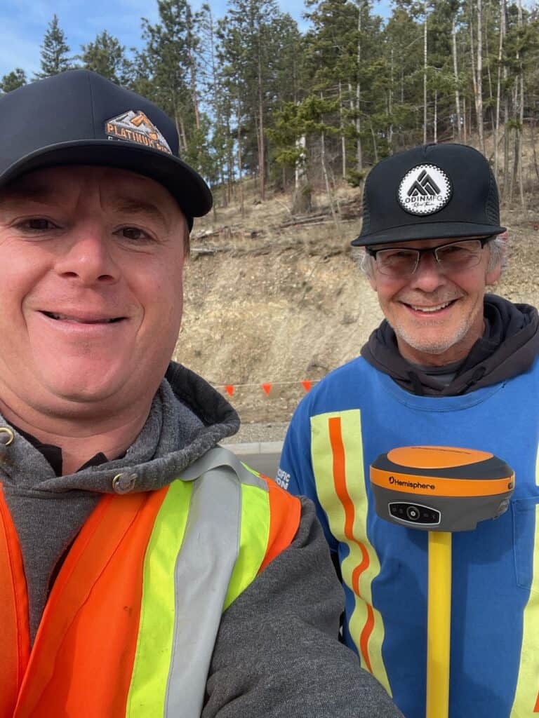
For surveyors who have spent their careers using manual equipment, the idea of transitioning to GPS technology can be intimidating. Jim, one of our clients from this summer, is a prime example of how this transition can be smoother than expected. A seasoned professional with years of experience using manual total stations and levels, Jim knew his tools well but found them increasingly limiting. He wanted to adopt GPS technology to improve his efficiency but had no prior experience with it.
When Jim purchased his RTK GPS system from me, he was scared about the complexity of the new equipment and how he was going to learn how to use it. However, within three hours of receiving the gear, he was ready to begin surveying confidently. This quick turnaround was made possible by Benchmark’s three-tiered approach to training and support.
First, we sent Jim had our online training academy, Survey-Assistant.com, a 24/7 resource designed to help surveyors learn at their own pace. Next, we got him seated in our live Zoom training sessions, where he could interact with Nolan and get real-time answers to his questions. Finally, our on-demand technical support team was available to assist with any challenges he faced in the field. Together, these resources ensured that Jim could integrate RTK GPS into his workflow seamlessly.
Today, Jim is working faster and more efficiently than ever. Operating in a hot climate, he takes advantage of the early mornings to complete his surveys, leveraging the speed and ease of his GPS system to maximize productivity.
RTK GPS excels in open or semi-open environments where satellite signals are strong and unobstructed. It is the preferred choice for topographic surveys, large-scale boundary work, construction staking across expansive sites, and infrastructure monitoring. When speed and single-operator efficiency are priorities RTK GPS is almost always the faster, more cost-effective option.
Traditional methods still hold their ground in specific scenarios. Interior surveys, underground utility work, heavily forested areas with extremely dense canopies, and tasks requiring precise short-range angle measurements in confined spaces can all favor optical instruments. If you’re working in an urban canyon surrounded by tall buildings that severely degrade satellite signal quality, a total station may deliver more reliable results for that particular setup.
In many workflows, the two methods are complementary rather than mutually exclusive. A surveyor might use RTK GPS to quickly establish control points across a large site and then switch to a total station for high-precision detail work in a specific zone.
The practical advantages of RTK GPS become most visible when you look at how surveyors have applied it in the field. Here are a few examples that illustrate the difference it can make.
A two-person crew using a manual total station estimated a multi-day job to traverse and verify boundary lines across a 200-acre rural property. After switching to an RTK GPS rover with network corrections, a single operator completed the same survey in one day. The elimination of traverse setups and the ability to cover ground quickly without line-of-sight constraints made the difference.
On a highway expansion project, the project team initially relied on total stations to set stakes along several kilometers of alignment. The process required constant instrument moves and a rod person working ahead. After integrating RTK GPS into the workflow, staking productivity increased significantly, with one operator handling the rover independently and checking into control points to verify accuracy throughout the day.
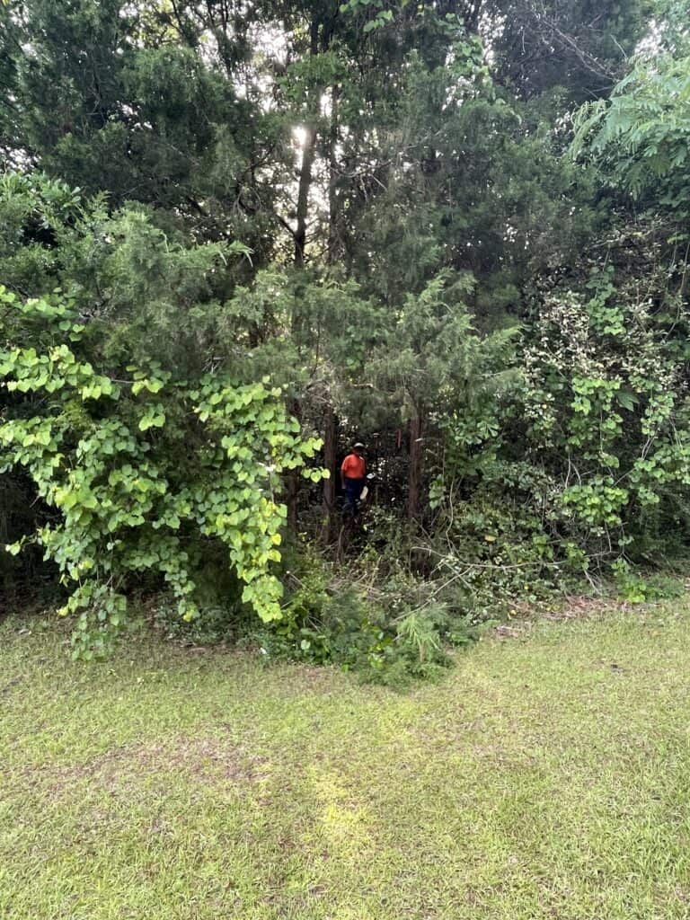
One of our customers attempted a boundary survey in a heavily treed area of British Columbia using a Hemisphere S631. Historically, this type of environment would have been a total station job by default. With the S631’s advanced signal tracking, the crew was able to maintain centimeter-level accuracy under canopy conditions that would have defeated older GPS receivers. While some areas required extra care and additional observation time, the overall survey was completed faster than a traditional traverse would have allowed.
These examples reinforce a broader point: the right equipment, paired with a solid understanding of its capabilities and limitations, consistently outperforms a one-size-fits-all approach.
The transition from traditional methods to RTK GPS represents more than just a change in tools—it’s a complete evolution in how surveyors approach their work. Traditional equipment, while dependable, is often labor-intensive and time-consuming. In contrast, RTK GPS streamlines workflows, reduces setup times, and allows surveyors to cover larger areas with greater efficiency.
The independence offered by RTK GPS is another major advantage. Tasks that might require a team of two or more people with traditional equipment can often be handled by a single operator using GPS. This not only reduces labor costs but also allows surveyors to take on more projects in less time, enhancing their overall profitability.
While traditional methods may have a lower upfront cost, the long-term benefits of RTK GPS make it a cost-effective choice. Faster project completion times, reduced manpower requirements, and minimized errors contribute to significant savings over time. For surveyors who are willing to invest in their future, the advantages of RTK GPS far outweigh the initial expenses.
Making the switch to RTK GPS involves more than just acquiring new equipment. It requires learning new workflows and ensuring the technology integrates seamlessly into daily operations. At Benchmark, we understand these challenges and are committed to supporting surveyors every step of the way.
Our comprehensive training programs are designed to address the learning curve associated with GPS technology. The online training academy allows users to learn at their convenience, while live Zoom sessions provide opportunities to interact with experts and clarify doubts. On-demand technical support ensures that no issue goes unresolved, giving surveyors the confidence to tackle any task.
The benefits of RTK GPS extend beyond efficiency and accuracy. For surveyors looking to stay competitive in a rapidly evolving industry, adopting this technology is a strategic move. RTK GPS systems are continually improving, incorporating features like cloud connectivity, mobile app integration, and advanced data analysis tools. By transitioning now, surveyors can future-proof their practices and remain at the forefront of technological innovation.
To learn more about what system is the best for you, check out this video where I talk about whether or not a base and rover or network rover makes more sense.
At Benchmark, we pride ourselves on offering the best service in North America. Our commitment to customer satisfaction is evident in every aspect of our business, from training and support to our satisfaction guarantee. We believe that with the right tools and guidance, any surveyor can successfully transition to RTK GPS and unlock new levels of productivity and profitability.
If you’re ready to revolutionize your workflow like Jim, contact us today. Our team is here to help you make the leap to GPS technology with confidence and ease.
Traditional surveying methods rely on optical tools like manual total stations and levels to measure angles and distances, requiring significant time and manpower. RTK GPS, on the other hand, uses satellite data to provide real-time corrections for precise positioning. This technology eliminates the need for line-of-sight measurements, enabling faster and more efficient surveys, often with a single operator.
Both methods are highly accurate, but RTK GPS provides real-time centimeter-level precision without the compounding errors that can occur during traditional traversing. Additionally, RTK GPS excels in areas with complex topography where maintaining line-of-sight is challenging, ensuring consistent accuracy even in dense canopies or urban environments.
The primary challenges include learning to operate the equipment and integrating the technology into existing workflows. However, these challenges can be overcome with proper training and support. At Benchmark, we offer resources such as an online training academy, live Zoom sessions, and on-demand technical support to ensure a smooth transition.
While RTK GPS has a higher upfront cost, it offers significant long-term savings through reduced labor, faster project completion, and minimized errors. Many surveyors find the investment pays off quickly as they can take on more projects and complete them with greater efficiency and fewer resources.
With the right training and support, new users can get up to speed quickly. For example, one of our clients, Jim, was ready to start surveying confidently within three hours of receiving his RTK GPS equipment, thanks to Benchmark’s comprehensive training program and responsive support team.
Bench Mark Equipment & Supplies is your team to trust with all your surveying equipment. We have been providing high-quality surveying equipment to land surveyors, engineers, construction, airborne and resource professionals since 2002. This helps establish ourselves as the go-to team in Calgary, Canada, and the USA. Plus, we provide a wide selection of equipment, including global navigation satellite systems, RTK GPS equipment, GNSS receivers, and more. We strive to provide the highest level of customer care and service for everyone. To speak to one of our team today, call us at 403-286-0333 or email us at [email protected].
