


As an owner or manager of an earthmoving or dirt-moving company, you know that precision, efficiency, and cost control are critical to maintaining profitability. One technology that can significantly impact your bottom line is Real-Time Kinematic (RTK) positioning. RTK is a high-precision GPS-based technology that can optimize your workflow, minimize costly mistakes, and reduce reliance on surveyors.
This article expands on the applications of RTK technology and demonstrates how integrating it into your earthmoving operations can lead to substantial cost savings and improved project efficiency. Check out our video below!
What is RTK and How Does it Work?
Key Applications of RTK for Earthmoving Businesses
Real-World Cost Savings: A Case Study
Getting Started with RTK: What You Need
How Difficult is it to Get Started with RTK?
RTK positioning enhances standard GPS accuracy from about half a meter to centimeter-level precision. This is achieved through a base station (either a physical unit on-site or a network-based solution like an NTRIP or VRS system) that sends correction signals to an RTK-enabled rover (receiver). The rover interprets these signals and provides precise centimeter level accuracy location data in real-time.
Modern RTK systems achieve this level of precision by tracking carrier-phase satellite measurements rather than relying solely on standard GPS positioning. Most professional RTK receivers operate on multil-frequency signals (typically L1, L2, and L5), allowing them to resolve positioning errors more quickly and maintain reliable fixes under challenging conditions. While single-band RTK receivers exist, multil-frequency systems generally deliver faster initialization times, greater reliability, and improved accuracy.
Today’s RTK receivers also support multiple satellite constellations, including GPS, GLONASS, Galileo, and BeiDou. Access to more satellites improves positioning performance, especially on sites where buildings, equipment, or terrain may partially obstruct the sky.
Corrections can come from an owned base station placed on the project site or from a network RTK service that delivers corrections through the internet. Both approaches provide centimeter-level positioning, but the best choice depends on project size, coverage requirements, and operating costs.
For an earthmoving company, this means operators can work with pinpoint accuracy when grading, leveling, or excavating—ensuring they move exactly the right amount of earth and reducing the need for rework. You can learn more about how RTK works here: Introduction to RTK GPS in Land Surveying.
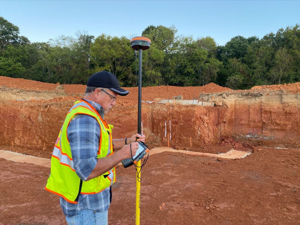
Many earthmoving companies assume RTK requires owning and setting up a base station on every project. In reality, many contractors now use Network RTK services delivered through NTRIP (Networked Transport of RTCM via Internet Protocol).
With this approach, the rover receives correction data through a cellular connection from a network of continuously operating reference stations. This eliminates the need to deploy and manage a local base station while still providing centimeter-level positioning accuracy.
For companies working across multiple job sites, Network RTK can significantly reduce setup time and simplify operations. However, contractors should account for ongoing subscription fees and ensure reliable cellular coverage is available throughout the project area.
Many contractors searching for RTK vs GPS are surprised by how large the accuracy difference actually is. Standard GPS commonly provides accuracy in the range of ±3–5 meters. That level of accuracy may be acceptable for navigation, vehicle tracking, or general location services, but it is completely unsuitable for precision earthmoving.
Consider a grading project where a finished surface must meet design elevations within a few centimeters. A standard GPS position that is several feet off could result in significant over-cutting, under-filling, material waste, and expensive rework.
RTK changes the equation by improving positioning accuracy to approximately ±1–2 centimeters under good conditions. This allows operators to confidently check grades, stake designs, verify elevations, and guide equipment with the precision required for modern construction projects.
One of the most immediate benefits of RTK technology is its ability to enhance grading accuracy. Whether you’re working on roads, building pads, or large excavation projects, RTK allows you to:
Using RTK, your operators can work more efficiently, minimizing material waste and avoiding costly rework. RTK allows you to check your progress as well as guiding your equipment helping minimizing mistakes and work being done multiple times.
Accurate stockpile management is essential for managing material costs and ensuring project efficiency. With RTK, you can:
Optimize material allocation by knowing exactly how much earth needs to be moved.
By performing stockpile surveys yourself, you can cut costs and improve project planning. By properly tracking your stockpiles and volumes you can again avoid mistakes that cost you money.
If your projects involve setting up site layouts for roads, buildings, or other infrastructure, RTK can drastically streamline the process. Instead of relying on expensive surveying teams, your crew can:
This not only speeds up the workflow but also ensures compliance with design specifications. You don’t need to entirely rely on someone else being available when you need them to make an adjustment based on what you are encountering in the field. You have the ability to respond to what you see in the field.
Hiring out a professional land surveyor can be really expensive, as well as difficult to find one who is available when you need them. While there are most certainly engineering tasks that still require professional surveyors, like laying out boundaries and initial design work, RTK allows your team to handle many day-to-day measurements and layout tasks in-house. This results in:
For a small to mid-sized earthmoving company, this can translate into thousands of dollars in annual savings.
Proper documentation of completed work is essential for both legal compliance and future project references. RTK can be used to create precise as-built records, including:
This helps prevent disputes and ensures your work meets contractual and regulatory requirements. Furthermore, if you are placing underground assets like sprinklers, piping, wiring and more RTK can be used to precisely locate them and return to those assets. With the centimeter level accuracy RTK provides, you can avoid costly mistakes by digging in the wrong place (or the wrong thing up). Check out how RTK can be used in the below video to locate sprinklers and compare it to your phone!
Even if you already use RTK in your machines through machine control, you can save big money with your own RTK system. One of our customers saved over $35,000 per year in subscription costs alone by transitioning to their own RTK-based machine control base stations that they controlled. The key savings came from:
For an earthmoving company, similar savings can be achieved by integrating RTK into everyday operations. You can check out our video on how they did it below:
If you’re considering RTK for your earthmoving business, you’ll need:
– RTK Receiver: This is the main device that receives corrections from the base station. Options include the GeoMeasure Nano 7 and the Hemisphere S631.
– Base Station or Network Subscription: Depending on your needs, you can set up a physical base station or subscribe to an RTK network service. You can either own your own local base station, like one of the above mentioned receivers or by subscribing to a network like SmartNet, Can-Net, Topnet, or building your own network with a service like our own StormCaster.
– Field Software: Applications like FieldGenius allow you to manage RTK data and integrate it into your machine control systems.
– Tablet or Controller: A rugged tablet or specialized controller will display RTK data and help operators navigate the site efficiently. Options include Windows 11 tablets like the Juniper Mesa 4 and the GeoMeasure BMT8. You want to ensure the tablet you are getting is a rugged water proof tablet that can stand up to the conditions in the field.
Many providers, including Benchmark, offer training and support to help businesses integrate RTK into their workflows quickly and efficiently.
The cost of RTK equipment varies considerably depending on the level of accuracy, durability, and functionality required.
Beyond the receiver itself, contractors should budget for additional equipment such as rugged tablets or controllers, which often range from several hundred dollars to several thousand dollars depending on specifications.
If using Network RTK, subscription fees may also apply. Depending on the provider and region, NTRIP or CORS subscriptions can range from a few hundred dollars per year to well over a thousand dollars annually.
Understanding both the upfront equipment costs and ongoing operating expenses is important when evaluating the overall return on investment of an RTK system.
One of the easiest ways to evaluate RTK is to compare its cost against the surveying and productivity expenses it replaces.
Consider a contractor who currently pays $500 for a surveyor visit twice per month for grade checks, layout verification, or stockpile measurements. That represents approximately $12,000 annually in outsourced surveying costs alone.
If the contractor purchases a professional RTK system for $6,000, the equipment could theoretically pay for itself within the first year simply by reducing routine survey call-outs.
The savings often extend beyond direct surveying costs. If RTK saves just one hour of setup, layout, or rework time per day and the crew’s billable rate is $100 per hour, that efficiency gain alone represents approximately $2,000 per month in recoverable value.
Actual results vary by business, but many contractors discover that RTK pays for itself much faster than initially expected once labor savings, material savings, and reduced downtime are considered together.


Getting started with new technology can be really intimidating. There is a common idea that learning how to use RTK is difficult. It really isn’t, especially if you have an equipment supplier that can provide you the resources to make it easy to learn the equipment. Here at Bench-Mark we offer the following:
The financial case for RTK GPS comes down to a few core areas where costs consistently bleed out of earthmoving projects and where RTK directly plugs the gaps.
Surveying is one of the biggest. Professional surveyors are expensive and not always available when you need them. By bringing routine layout, grade checks, and volume measurements in-house with RTK, you eliminate both the expense and the scheduling bottleneck. For many companies, this alone accounts for thousands of dollars saved per year.
Material waste is another major factor. Over-cutting or overfilling on a grading job adds up fast in both material costs and the labor required to fix it. RTK’s centimeter-level accuracy means operators work to spec the first time, reducing both overages and rework.
Then there’s machine efficiency. Whether you’re running machine control or simply using RTK to guide your crew, fewer passes and faster setups translate directly to lower fuel, labor, and equipment wear costs per project.
Finally, owning your own RTK infrastructure rather than relying on subscription-based correction networks can eliminate recurring per-machine fees that scale quickly across a larger fleet as demonstrated by the $35,000 annual saving highlighted in the case study above.
Add it all together, and RTK GPS is one of the highest-return investments an earthmoving business can make.
RTK technology is a game-changer for earthmoving businesses looking to improve efficiency, reduce costs, and enhance accuracy. Whether you’re grading land, managing stockpiles, or setting up infrastructure, RTK can streamline your workflow and maximize profitability.
RTK (Real-Time Kinematic) GPS enhances standard GPS accuracy from about half a meter to centimeter-level precision. It achieves this by using a base station that sends correction signals to an RTK-enabled rover, allowing for precise location data in real-time.
RTK can reduce costs by minimizing surveying expenses, decreasing material waste, improving efficiency in earthmoving operations, and preventing costly rework. Some companies have saved over $35,000 per year by switching to RTK-based systems.
While professional surveyors are still necessary for boundary work and initial designs, RTK allows businesses to handle routine measurements, site layouts, and stockpile management in-house, reducing dependency on external surveyors.
To implement RTK, you’ll need an RTK receiver, a base station or network subscription, field software (such as FieldGenius), and a rugged tablet or controller to display and manage RTK data.
No, RTK is straightforward to use, especially with proper training. Suppliers like Bench-Mark offer live Zoom training, online tutorials, and real-time support to help businesses integrate RTK into their workflow efficiently.
Yes. RTK GPS is widely considered one of the most cost-effective investments an earthmoving or construction business can make. The upfront cost of equipment is typically recovered quickly through savings on surveying fees, reduced material waste, fewer rework events, and lower subscription costs if you own your own base station infrastructure.
RTK can successfully handle many routine construction tasks, including grade checking, staking, stockpile measurement, utility location recording, and site layout. However, licensed surveyors are still required for legal boundary determinations, control establishment, and other professional surveying services.
Multi-frequency RTK receivers track multiple satellite frequencies, typically L1, L2 and L5. Compared to single-band systems, they generally achieve faster fixes, maintain accuracy more reliably, and perform better in challenging environments. For most professional earthmoving and construction applications, multi-frequency RTK is the preferred option.
Traditional base-and-rover RTK systems commonly operate over several kilometers. Network RTK services can provide coverage across much larger regions through interconnected reference station networks.
RTK is the positioning technology that provides centimeter-level accuracy. Machine control GPS uses RTK positioning data to guide construction equipment such as dozers, graders, and excavators. In other words, RTK supplies the accurate location information, while machine control systems use that information to improve grading and excavation performance.
Bench Mark Equipment & Supplies is your team to trust with all your surveying equipment. We have been providing high-quality surveying equipment to land surveyors, engineers, construction, airborne and resource professionals since 2002. This helps establish ourselves as the go-to team in Calgary, Canada, and the USA. Plus, we provide a wide selection of equipment, including global navigation satellite systems, RTK GPS equipment, GNSS receivers, and more. We strive to provide the highest level of customer care and service for everyone. To speak to one of our team today, call us at 403-286-0333 or email us at [email protected].
