


Real-Time Kinematic (RTK) is a cutting-edge positioning technique that has revolutionized land surveying by providing centimeter-level accuracy in real-time. Since the introduction of RTK as a high-precision positioning solution, it has become essential for industries that require exact measurements, like those often found in construction, agriculture, and boundary mapping. RTK and real-time kinematic gps surveying leverage signals from global satellite systems like GPS, GLONASS, BeiDou and Galileo to calculate positions to within a centimeter, eliminating many common errors associated with standard GNSS. By using a base station to provide real-time correction data to mobile rovers, RTK ensures that surveyors and engineers can trust the data they gather, leading to more reliable project outcomes.
For land surveyors, understanding RTK technology is key to staying competitive and efficient in a field where precision is everything. The applications of RTK extend beyond just land measurement; it’s used to guide construction machinery, support precision farming, and create detailed maps for Geographic Information Systems (GIS). Whether you’re conducting cadastral surveys to define property boundaries or building infrastructure with exact specifications, RTK offers a reliable solution for achieving pinpoint accuracy in real-time. By investing in RTK knowledge and equipment, professionals can enhance their workflows and take on more complex surveying projects with confidence.
What Do I Need in an RTK Setup?
How to Use RTK in Surveying: Step-by-Step Workflow
Where Can You Learn How to Use RTK?
Applications of RTK in Land Surveying
RTK Options and Considerations
Definition of RTK
Real-Time Kinematic (RTK) is a positioning technique that uses data from Global Navigation Satellite Systems (GNSS) such as GPS, GLONASS, Galileo, and BeiDou to provide precise positioning data in real-time. Unlike standard GNSS, which offers positioning accuracy of around 1 to 3 meters, RTK can achieve centimeter-level accuracy—critical for tasks that require high precision, such as land surveying, construction, and mapping.
Importance of Accuracy in Surveying
In land surveying, the accuracy of measurements can significantly impact the outcome of projects. For example, in cadastral surveys that define legal land boundaries, even slight errors can lead to disputes or legal complications. Similarly, in construction, accurate measurements are crucial to ensure structures are built in the correct locations. RTK addresses these challenges by delivering the high precision needed for these tasks, with repeatability between measurements within a centimeter possible.
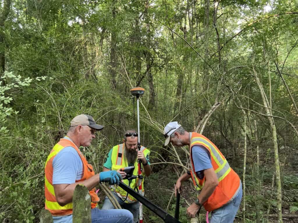
RTK being used for the establishment of ground control points for a site survey to be used in a topographic survey.
The Role of GNSS and Differential Correction
RTK relies on GNSS signals for positioning. A typical GNSS receiver calculates its position using satellite signals, but these signals are subject to various error sources, such as atmospheric interference, satellite clock drift, and multipath errors (when signals bounce off surfaces before reaching the receiver). For a more detailed look at how a GNSS receiver works, check out this article: How Does a GNSS Receiver Work?
RTK improves on traditional GNSS by employing a method called “differential correction.” A base station with a known, fixed location compares the GNSS data it receives to its actual location. It then calculates the error in the GNSS signals and transmits correction data to a mobile rover (another GNSS receiver), which adjusts its positioning data in real-time based on the base station’s corrections.
Real-Time Data Transmission
RTK corrections are transmitted from the base station to the rover using communication systems such as UHF/VHF radios or cellular networks. The corrections allow the rover to achieve centimeter-level accuracy in real time, without the need for post-processing.
Error Sources and Mitigation
Even with RTK, several factors can affect the accuracy of positioning and the performance of the receiver:
Surveyors can mitigate these errors by ensuring a clear line of sight between their base station or rover and the sky. This will keep the largest number of satellites in view, giving the receiver the best possible data.
To implement RTK, specific equipment is necessary. There are typically two different types of setups, a base and rover or a network rover. Below are the essential components:
RTK Base Stations and Rovers
Base Station: A GNSS receiver installed at a fixed, known location. It acts as a reference point, transmitting correction data to the rover.
Rover: A mobile GNSS receiver that applies correction data from the base station in real time to calculate highly accurate positions.
Data Collector: A handheld computer that runs a software package like MicroSurvey’s FieldGenius. This software allows you to store positions, make calculations and more in the field.
Network Rover
Rover: A mobile GNSS receiver that applies correction data from the base station in real time to calculate highly accurate positions. A SIM card or mobile hotspot is used to connect to an NTRIP network.
Data Collector: A handheld computer that runs a software package like MicroSurvey’s FieldGenius. This software allows you to store positions, make calculations and more in the field.
Communication System: UHF, VHF, and Internet
The base station and rover need to communicate, and this can be done through several methods:
Using RTK in surveying requires a reliable correction source, a properly configured rover, and careful field checks. The goal is to collect accurate survey data in real time while confirming that the setup is working correctly.
Surveyors usually work with one of two RTK setups:
A base and rover setup gives more control on local or remote projects. Network RTK is often faster to start, but it depends on cellular coverage and network availability.
Before collecting points, check the coordinate system, datum, units, geoid model, antenna height, and project file settings. Incorrect settings can shift the entire survey, even when the rover shows a fixed RTK solution.
For a base and rover setup, place the base receiver on a stable tripod with a clear view of the sky. Enter the correct base coordinates and antenna height.
For network RTK, connect the rover to the correction service and choose the correct mountpoint. Confirm that the correction source matches the project coordinate system.
Connect the rover to the data collector and confirm that correction data is being received. Wait until the rover reaches Fixed RTK status before collecting important survey points.
If the rover does not fix, check satellite visibility, radio or cellular connection, correction settings, and possible obstructions such as trees, buildings, or vehicles.
Before starting the main survey, measure at least one known control point. This confirms that the coordinate system, antenna height, base setup, and correction source are correct.
For larger or higher-accuracy projects, check multiple control points across the site.
Once the setup is verified, collect points, lines, and features with the rover and data collector. Typical RTK survey data may include property corners, ground shots, breaklines, curbs, utilities, buildings, roads, and construction layout points.
Use clear point codes and descriptions so the data can be processed correctly later.
While collecting data, monitor the RTK status, number of satellites, correction age, signal strength, horizontal accuracy, vertical accuracy, and pole height. If accuracy becomes unstable, stop collecting important points until the issue is corrected.
Before leaving the site, recheck one or more control points to confirm that the RTK setup remained stable. Then review the data, check point descriptions, save the job file, and export the required format for CAD, GIS, or survey office software.
Learning RTK technology requires a blend of theoretical understanding and hands-on experience. Fortunately, several resources are available for professionals interested in gaining these skills.
Online Courses and Certifications
Several online platforms offer comprehensive courses on RTK technology and its applications in land surveying:
University Programs and Specialized Training Centers
Many universities and technical institutes offer courses or degree programs in geomatics, land surveying, or geospatial technologies that cover RTK in depth. Geomatic and civil engineering degrees provide you with all the information you need.
RTK is a versatile tool that has revolutionized multiple fields by providing real-time, high-precision positioning. In land surveying, its most prominent applications include:
Boundary and Cadastral Surveys
One of the primary uses of RTK is for boundary or cadastral surveys. These surveys are used to define the legal boundaries of properties and land parcels, making high precision essential. RTK ensures that surveyors can produce accurate, reliable maps that adhere to legal standards.
Construction and Infrastructure Development
In construction, RTK plays a key role in positioning machinery and marking points for building foundations, roads, pipelines, and other infrastructure. RTK-guided machines can excavate, grade, and lay materials with centimeter-level accuracy, reducing the need for rework and speeding up project timelines.
Agriculture and Precision Farming
In agriculture, RTK is used in precision farming to guide tractors and other machinery during planting, fertilization, and harvesting. Farmers can ensure their machinery operates efficiently, minimizing overlap and reducing waste. RTK allows for accurate field mapping, soil sampling, and crop monitoring.
Geographic Information Systems (GIS)
RTK technology is commonly used in GIS applications to collect spatial data with high accuracy. RTK-enabled devices allow surveyors and geospatial professionals to create detailed and precise maps, essential for planning, resource management, and environmental monitoring.
A Hemisphere S631, 7th generation RTK receiver used during a topographic survey. The Hemisphere S631 is a high-performance receiver at an affordable price.
RTK vs. PPK (Post-Processed Kinematic)
While RTK delivers real-time corrections, another similar method is PPK (Post-Processed Kinematic). Unlike RTK, PPK doesn’t require real-time correction data transmission. Instead, data is recorded and processed after the survey, allowing for accurate positioning in scenarios where real-time communication isn’t feasible. PPK is often used in areas with poor signal coverage or when extreme precision is needed.
Free vs. Subscription-Based Correction Services
RTK users often have the option to either:
RTK Equipment Pricing and Budget Considerations
RTK equipment can range from several thousand to tens of thousands of dollars, depending on the manufacturer, precision level, and additional features. Surveyors must carefully consider their project requirements and budget constraints when selecting equipment. Rental options are also available for those who need RTK technology on a project basis.
A good RTK survey starts with the right equipment, correct settings, and reliable corrections. Before fieldwork begins, confirm that all equipment is charged, configured, and ready for use.
Base and Rover Checklist
Before collecting points with a base and rover setup, confirm that:
Before using Network RTK, confirm that:
Before collecting RTK data, verify:
The Future of RTK in Land Surveying
As GNSS technology advances, the accuracy and reliability of RTK systems will continue to improve. With the integration of more satellite constellations, enhanced communication systems, and better data processing algorithms, the role of RTK in land surveying and positioning is set to grow. As a result, surveyors who understand and utilize RTK will have a significant advantage in delivering high-quality, precise measurements.
For professionals looking to enter or advance in land surveying, understanding RTK is essential. Start by gaining a solid foundation through online courses or university programs, and invest in quality equipment that suits your project needs. By mastering RTK technology, you will be well-prepared to tackle the demands of modern surveying and positioning projects.
Real-time kinematic is a high-precision positioning technique that leverages Global Navigation Satellite Systems (GNSS), such as GPS, GLONASS, Galileo, and BeiDou, to provide centimeter-level accuracy in real-time. It improves on traditional GNSS by using a base station to send correction data to a mobile receiver (rover), making it ideal for applications like land surveying, construction, and agriculture.
RTK works by using a base station, which is a fixed GNSS receiver, to compare its known location to satellite data. It calculates the difference (correction data) and sends it to a rover, which adjusts its position in real-time. This process allows surveyors to achieve accurate positioning within centimeters, essential for defining legal land boundaries and construction.
An RTK setup typically consists of a base station (for sending correction data), a rover (for receiving and applying corrections), a data collector, and a communication system (UHF/VHF radios or cellular networks) to transmit the correction data. Some setups may use network rovers, which connect to correction services like CORS (Continuously Operating Reference Stations) via the internet.
RTK is commonly used for boundary and cadastral surveys, ensuring precise mapping of property boundaries. It also plays a significant role in construction for machine control, marking building points, and positioning infrastructure. Additionally, RTK is widely used in precision farming and Geographic Information Systems (GIS) for creating accurate maps and managing resources effectively.
The principle of RTK is based on differential correction using a base station and a rover. The base station, placed at a known fixed location, calculates errors in satellite signals by comparing the measured position to its true coordinates. These corrections are transmitted to the rover, which adjusts its calculated position in real-time. By applying these real-time kinematic corrections, RTK eliminates common GNSS errors and enables centimeter-level positional accuracy for surveying and mapping applications.
Bench Mark Equipment & Supplies is your team to trust with all your surveying equipment. We have been providing high-quality surveying equipment to land surveyors, engineers, construction, airborne and resource professionals since 2002. This helps establish ourselves as the go-to team in Calgary, Canada, and the USA. Plus, we provide a wide selection of equipment, including global navigation satellite systems, RTK GPS equipment, GNSS receivers, and more. We strive to provide the highest level of customer care and service for everyone. To speak to one of our team today, call us at 403-286-0333 or email us at [email protected].
