

A traditional survey crew walking transects across a 200-hectare site in northern Ontario might spend a week collecting enough data to produce a basic topographic map. A UAV equipped with a calibrated photogrammetry payload can fly the same area in a few hours, returning thousands of overlapping images that process into a centimetre-resolution orthomosaic, a digital surface model, and a georeferenced point cloud, all before the traditional crew would have finished their second day.
That gap represents a fundamental shift in how geospatial data is collected, and it’s reshaping what surveyors, engineers, and construction professionals can deliver to their clients.
What “Aerial Drone Surveying” Actually Means
Photogrammetry vs. LiDAR: Choosing the Right Sensor
Where Aerial Drone Surveys Deliver the Most Value
The Role of RTK GNSS in Drone Survey Accuracy
Flight Planning and Regulatory Reality in Canada
Limitations Worth Knowing Before You Commit
The Surveyor’s Tool, Not the Surveyor’s Replacement
The term gets used loosely, so it’s worth being precise. An aerial drone survey is a structured data collection mission flown by an unmanned aerial vehicle (UAV), where the primary output is geospatial data, coordinates, elevations, or imagery, accurate enough to be used in professional deliverables. This distinguishes it from recreational or inspection drone use. The outputs of a proper aerial drone survey are the same kinds of products a ground-based survey crew would produce: topographic data, volumetric calculations, site plans, and as-built records.
There are two main UAV platforms used in professional surveying:
The sensor package matters as much as the platform. Survey drones typically carry one of two primary sensor types: a calibrated RGB camera for photogrammetry, or a LiDAR scanner for direct point cloud generation. Each has a distinct performance profile in the field.
Photogrammetry uses overlapping aerial images processed through structure-from-motion (SfM) software to reconstruct 3D geometry. It’s cost-effective, produces highly detailed visual deliverables, and works extremely well in open terrain with good lighting. The limitation is vegetation: photogrammetry models the surface it can see, so dense ground cover can obscure the actual ground surface beneath it.
LiDAR emits laser pulses and measures their return time to generate a direct point cloud. Because it fires millions of pulses per second, some will penetrate through gaps in vegetation and return from the ground below. This makes LiDAR the preferred sensor for forested terrain, wetland mapping, and any project where true ground elevation beneath cover matters.
For most construction and development projects in Canada, open sites, disturbed land, active subdivisions, and road corridors, photogrammetry delivers the accuracy and resolution needed at a significantly lower equipment cost. LiDAR earns its premium in environments where photogrammetry simply can’t reach the ground.
Not every project benefits equally from UAV deployment. The strongest use cases share a few common characteristics: large area extent, a need for dense spatial data, difficult or dangerous ground access, or a tight schedule that traditional methods can’t meet.
The industries where aerial drone surveying consistently delivers measurable value include:
What these applications share is scale and complexity that would make conventional ground survey either impractical on time grounds or genuinely dangerous for field personnel.
This is where many drone survey workflows either succeed or fall short. A drone flying a grid pattern captures imagery, but those images need accurate geospatial reference to produce survey-grade deliverables. There are two approaches: ground control points (GCPs) or onboard RTK/PPK GNSS.
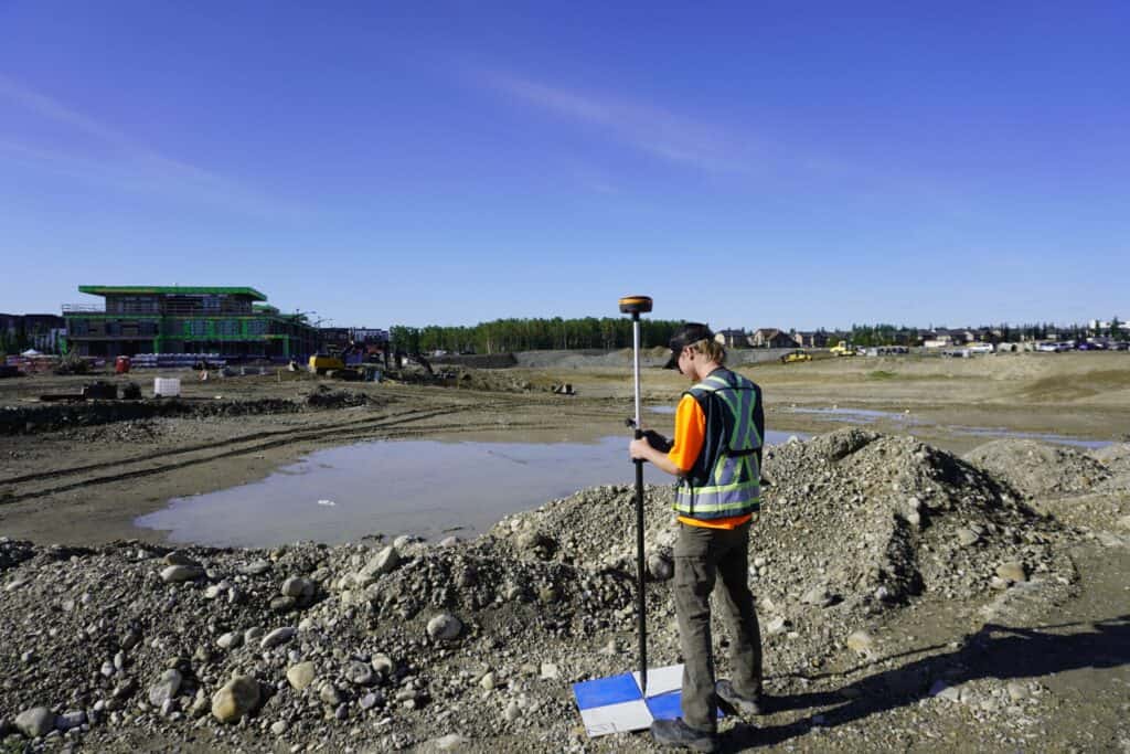
GCPs are physical targets placed at surveyed positions across the site before the flight. Their known coordinates anchor the photogrammetric model during processing. This approach requires ground survey work, typically an RTK GNSS rover, to establish the GCP positions with centimetre accuracy before the UAV goes up.
Onboard RTK integrates a GNSS receiver directly into the drone, tagging every captured image with a precise position at the moment of capture. High-quality onboard RTK can reduce or eliminate the need for GCPs on many projects, though some survey standards still require a minimum number of check points for verification.
Either way, the accuracy of your ground control or onboard positioning defines the accuracy of everything downstream. At Bench-Mark, we support survey crews integrating UAV workflows who need their ground control established to the standard that drone-based deliverables demand. The Hemisphere S631 is the RTK system most of our Canadian clients rely on for GCP establishment, it provides the fix stability and accuracy needed to anchor a photogrammetric model correctly.
A professional aerial drone survey doesn’t start with a takeoff, it starts with a flight plan. Key variables that shape mission design include the required ground sampling distance (GSD), which determines the flying altitude; the overlap percentage between adjacent image strips, which drives the photogrammetric reconstruction quality; and site-specific factors like terrain variation, wind exposure, and proximity to controlled airspace.
In Canada, commercial drone operations fall under Transport Canada’s Remotely Piloted Aircraft System (RPAS) regulations. Drones over 250 grams require registration, and commercial operators working in controlled airspace or complex operations need a Basic or Advanced RPAS pilot certificate. Before any survey flight, pilots must check NOTAMs, confirm airspace classification, and obtain any required authorizations through NAV CANADA’s online tools.
These aren’t bureaucratic friction, they’re the framework that keeps professional drone surveying credible and legally defensible. Clients receiving drone-based deliverables increasingly expect to see documentation that the flight was conducted in compliance with Transport Canada requirements.
Aerial drone surveying has real constraints that affect when it’s the right choice. Weather is a significant one: most survey UAVs have operating wind limits in the 10–12 m/s range, and low cloud, rain, or snow can ground a planned mission entirely. In Canada’s shoulder seasons, and in many northern regions year-round, scheduling drone flights around workable weather windows adds an element of uncertainty that ground-based survey doesn’t have.
Accuracy in vertical measurement also deserves attention. Photogrammetry-derived elevation data tends to perform better in horizontal than vertical, and achieving the vertical accuracy required for some engineering applications requires careful GCP design and processing validation.
Finally, dense urban environments present airspace complexity and line-of-sight requirements that can restrict where and how drone surveys are practically conducted.
Aerial drone surveying is one of the most powerful additions to a professional survey workflow in decades. But it works best when it’s integrated into a complete system, paired with proper ground control established by accurate RTK GNSS equipment, processed through reputable photogrammetry software, and delivered by operators who understand both the technology and the standards their clients require.
Bench-Mark works with survey and construction professionals across Canada who are building out or refining their UAV workflows. Whether the question is about the RTK equipment needed for ground control, the data collector software that connects field and office, or how to match the right tools to a specific project type, our team supports the full workflow. Because a drone that produces data no one can trust in the field isn’t an efficiency gain. It’s a liability.
