Modern mapping and surveying would be almost impossible without navigation satellites. Whether you’re charting a new highway, modeling terrain for a city, or creating a precision agriculture map, your ability to pinpoint exact locations on Earth hinges on a silent fleet of satellites orbiting overhead.
These navigation satellites are not just tools of convenience—they’re foundational to the geospatial industry. This article explains what they are, how they work, and why they’re indispensable in mapping and surveying today. Without them, your surveying work with RTK equipment would be impossible. Check out our 90 second explainer on how satellites work below:
What Is a Navigation Satellite?
How Navigation Satellites Work
Types of Navigation Satellites
Augmentation for Higher Accuracy
Applications in Mapping and Surveying
The Future of Navigation in Mapping
A navigation satellite is an artificial satellite that broadcasts timing and positional data via radio signals. These signals are received by ground-based devices, which use the information to calculate precise locations on Earth.
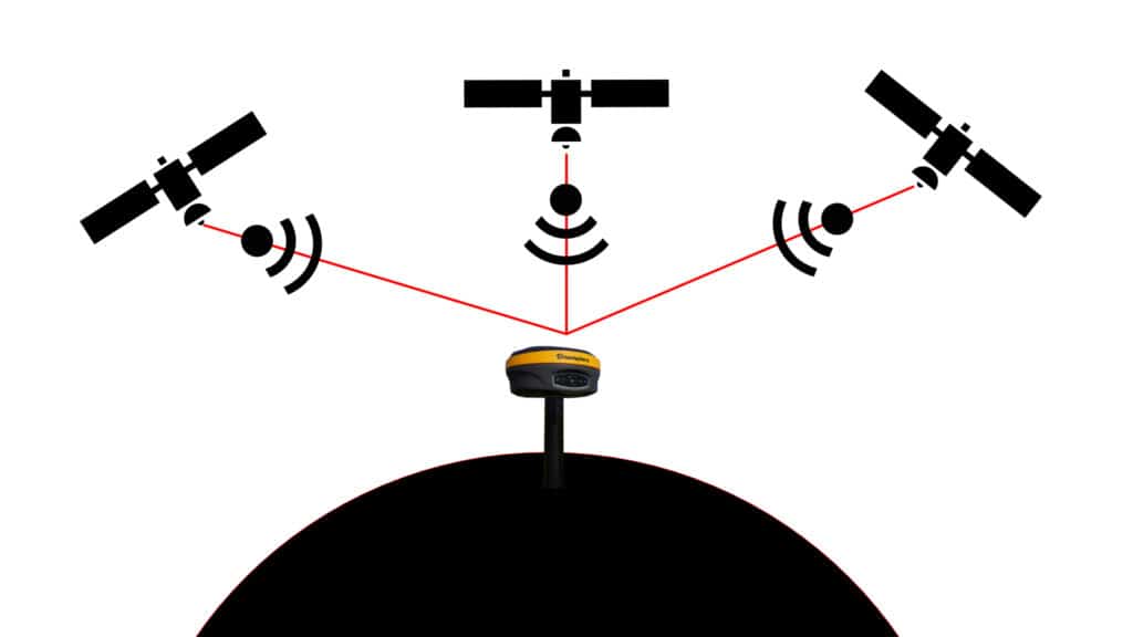
At their core, navigation satellites are flying radios equipped with extremely accurate atomic clocks. Each one constantly transmits its position and the exact time the signal is sent. A receiver on the ground—like a surveyor’s GNSS rover or a drone—can pick up these signals and calculate its distance from each satellite. Using signals from at least four satellites, it triangulates its exact position in three dimensions.
This system underpins nearly all modern mapping and surveying workflows—from GIS data collection and land parcel measurement to drone photogrammetry and 3D modeling.
Satellite navigation has become one of the most broadly applied technologies in the modern world. While mapping and surveying represent some of its most precise and demanding uses, the underlying infrastructure supports a much wider range of applications:
In the context of professional geospatial work, satellite navigation is the backbone of every workflow that depends on knowing where something is. The sections below explore exactly how that works.
1. Precision Timing and Distance Measurement
Each navigation satellite sends out a continuous radio signal containing two key pieces of information:
– A precise time the signal transmitted to an accuracy ≤30 nanoseconds 95% of the time (GPS Accuracy GPS.GOV). That is to a billionth of a second.
– The location and identity of the satellite. This allows you receiver to begin to calculate its position in reference to the satellite.
The signals travel from the satellite at a known speed ~186,000 miles per second (Global Positioning System NOAA). By measuring how long it takes for each signal to reach the receiver, the device calculates its distance to each satellite. This is done by measuring the number of cycles in the signal (and performing a lot of complex mathematics).
Once the distance to a number of satellites has been calculated, the receiver can then perform a trilateration calculation. This allows for the calculation of the receiver position. This allows it to determine its position on Earth to within a few meters, or even centimeters with correction systems. For a history on the evolution of the GPS constellation and positioning in general, check out the video below on GLONASS or my writeup and video on GPS: GPS in Surveying – From Weapon of War to Everyday Tool.
2. Carrier Waves and Signal Data
The information mentioned above is contained on the carrier wave signal from each satellite. The information is more complex than the simplified version above, with each signal containing:
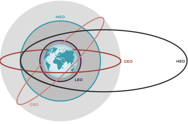
1. Geostationary Satellites
2. Medium Earth Orbit (MEO) Satellites
3. High Eccentric Orbit (HEO) Satellites
These satellites constantly move relative to the Earth’s surface, enabling global coverage. They make up the GNSS constellations used in field mapping and precise surveying.
Mapping professionals rely on one or more of these systems:
1. GPS (USA) – The most widely used. Offers solid performance globally. You can read more here: History of GPS.
2. GLONASS (Russia) – The second system that provided global coverage. The weakest constellation available to civilians with global coverage. See the above video for more information.
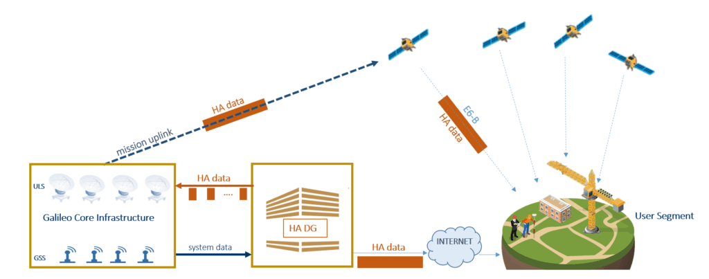
3. Galileo (EU) – Offers high precision and more advanced civilian signals. One of the only constellations developed primarily for civilians. With the introduction of the HAS signal, Galileo is one of the most advanced constellations for civilians.
4. BeiDou (China) – Rapidly expanding, now fully global. Has the most advanced and accurate civilian signal available.
Many professional receivers use all four systems to maximize satellite visibility and reduce signal blockage, especially in challenging terrain.
Mapping and surveying often demand accuracy beyond the standard 5–10 meter GNSS range, or augmented 0.5 m that SBAS can provide. That’s where augmentation systems come in:
These techniques are standard in tasks like:
Satellite navigation has transformed traditional surveying. Tasks that once took days with transits and tapes now take minutes with GNSS-enabled gear.
Land Surveying
With the ability of modern 7th generation, multi-constellation receivers to work under canopy, many surveyors are able to leave their total stations behind. Instead of having to cut sightlines through forests and tree canopy, the latest receivers are able to obtain fixed solutions under trees. With this capability, surveyors are able to complete projects in significantly less time than before. To see the difference, check out the difference between the 4th generation Hemisphere S320, which is GPS GLONASS only and the latest Hemisphere S631.
Construction & Civil Engineering
Similarly to the work in surveying, construction has also seen big improvements in efficiency with RTK. Some of the more obvious is the introduction of machine control technologies, where RTK is providing real-time grade control to machines in the field. Rather than operators having to manually check stakes, machines can automatically make real-time adjustments to blade height and angle. However, even users who have been performing grade checks with older RTK surveying equipment will see efficiency gains in the field. With the introduction of IMU tilt sensors, users can perform stakeout at twice the speed they previously could.
GIS Data Collection
One of the biggest revolutions that navigation satellites have provided us is the ability to map and track assets. With GNSS technology, users can quickly digitize their environments or keep track of their equipment in real-time. This has changed the way we manage municipal and corporate assets, allowing for better maintenance and sustainability practices. Check out our article on the subject: Municipal Asset Collection: Sub-Meter GIS or Centimetre Level RTK?
Drone Mapping
Photogrammetry has been around for long time, with appearances all the way back to the First World War (Read more here: Aerial Photography and the First World War). However, as drones like the DJI Mavic 3 and Matrice 350 integrate RTK data directly into images, we are now able to significantly reduce preparatory ground work and processing time.
Despite their power, satellite systems aren’t flawless—especially in mapping applications where precision is non-negotiable:
Mapping professionals mitigate these with techniques like:
As satellite navigation systems evolve, mapping and surveying are becoming faster, cheaper, and more accurate:
There is one big step that has been briefly mentioned earlier that is beginning to play a bigger and bigger role in mapping level positioning. Low-Earth orbit (LEO) satellite constellations and even the global systems are introducing PPP services that allow for an enhanced level of accuracy after allowing for a convergence time. This allows receivers to determine a position accurate to within 20 cm after 15 minutes, or better for free. There are also paid versions of the service that allow users to achieve an even better level of accuracy anywhere on Earth.
These services work by observing satellite signals at ground stations with a known position. This ground station can then provide corrections to satellites, improving their accuracy.
In mapping and surveying, navigation satellites aren’t just useful—they’re foundational. They allow professionals to collect geospatial data quickly and accurately, no matter the environment. By understanding how these satellites work and using the right augmentation tools, surveyors and mappers can achieve the pinpoint precision required for everything from national infrastructure to drone-based topographic modeling.
Navigation satellites are much more than space tech—they’re the invisible grid on which modern geospatial work is built.
To calculate a precise 3D location (latitude, longitude, and elevation), GNSS receivers need signals from at least four satellites. This allows the system to account for time discrepancies and triangulate an accurate position.
GPS is one of several GNSS (Global Navigation Satellite Systems). GNSS refers to the broader category that includes multiple satellite constellations like GPS (USA), GLONASS (Russia), Galileo (EU), and BeiDou (China).
Uncorrected GNSS typically offers 5–10 meter accuracy. With Satellite-Based Augmentation Systems (SBAS), that improves to about 0.5 meters. For centimeter-level accuracy, professionals use RTK, PPK, or static corrections.
Yes. Urban canyons, dense forests, and steep terrain can obstruct or reflect signals, causing errors. Using multi-constellation receivers and timing surveys for good satellite geometry can help mitigate this.
Geostationary satellites don’t help directly with positioning but are key in broadcasting correction data through augmentation systems like WAAS, helping improve GNSS accuracy in real-time.
Bench Mark Equipment & Supplies is your team to trust with all your surveying equipment. We have been providing high-quality surveying equipment to land surveyors, engineers, construction, airborne and resource professionals since 2002. This helps establish ourselves as the go-to team in Calgary, Canada, and the USA. Plus, we provide a wide selection of equipment, including global navigation satellite systems, RTK GPS equipment, GNSS receivers, and more. We strive to provide the highest level of customer care and service for everyone. To speak to one of our team today, call us at 403-286-0333 or email us at [email protected].
