
The Future of GPS Surveying: Integration with LiDAR and Photogrammetry
The surveying industry is undergoing a technological revolution, driven by advancements in GNSS technology and its integration with LiDAR (Light Detection and Ranging) and photogrammetry. This combination promises to enhance the accuracy, efficiency, and scope of surveying projects across various sectors. In this blog post, we will explore the future of GPS surveying, focusing on how its integration with DJI LiDAR and photogrammetry is transforming the industry.
The Evolution of GPS Surveying
Understanding LiDAR Technology
The Integration of GPS, LiDAR, and Photogrammetry
Benefits of Integrating GPS with LiDAR and Photogrammetry
The field of surveying has always been at the forefront of adopting new technologies to improve accuracy and efficiency. From the adoption of total stations, robotic total stations, to the earliest GNSS receivers, technology is constantly changing how we survey. As RTK systems become more and more ubiquitous and the technology only gets better and better, the integration of RTK into other technologies is the next frontier for the future of land surveying.
In recent years, the integration of GPS (Global Positioning System) with LiDAR (Light Detection and Ranging) and photogrammetry has begun a revolution that promises to again change the way we survey. This fusion of technologies offers unparalleled precision and comprehensive data collection capabilities, making it possible to undertake complex surveying projects with greater confidence, accuracy and speed. In this blog post, we will delve into the future of GPS surveying, focusing on its integration with LiDAR and photogrammetry, and explore how this synergy is transforming the industry.
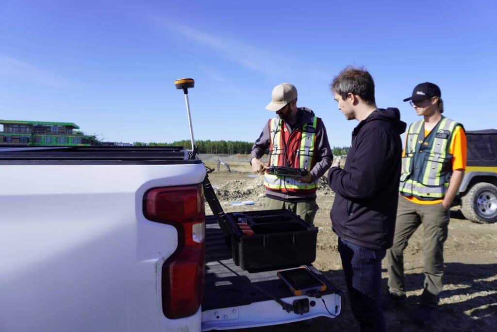
Hemisphere S631 being used for construction surveying.
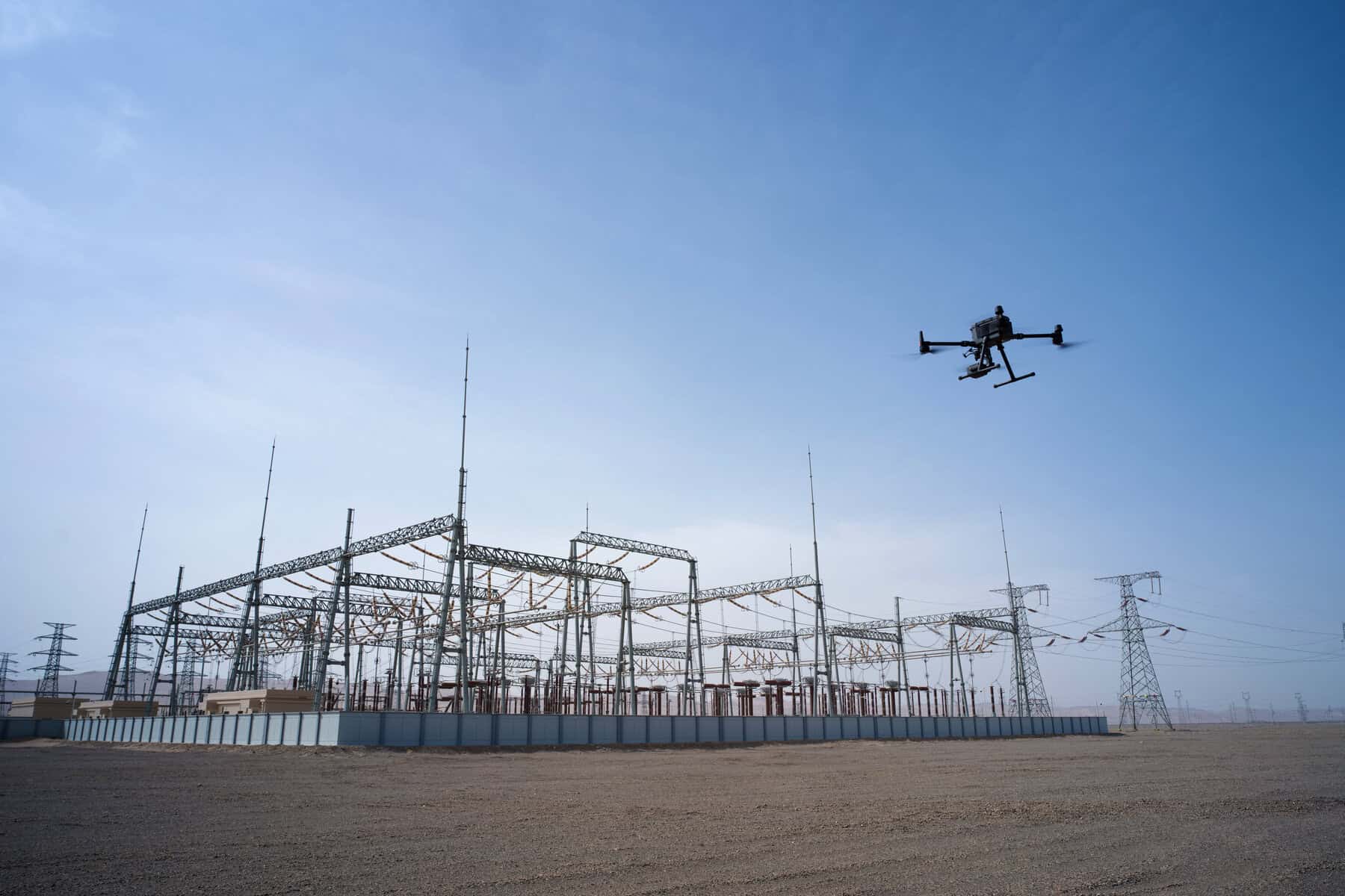
A DJI Matrice 350 with integrated LiDAR and photogrammetry unit used for the monitoring of power utilities.
GPS technology has come a long way since its inception. Originally developed for military navigation, GPS has become an indispensable tool in various civilian applications; from precision agriculture, asset tracking, server time management and more, but most importantly for us today, surveying. The ability to determine precise locations in real-time anywhere on Earth has revolutionized the way surveyors work.
Historical Perspective on GPS Technology in Surveying
The journey of GPS technology in surveying began in the 1980s when the first GPS satellites were launched. Early adopters in the surveying industry quickly recognized the potential of GPS to provide accurate and reliable positioning data. However, the technology had limitations, including signal interference and the need for extensive field calibration. The original civilian GNSS units for surveying were cumbersome units that took a lot of planning to maximize their use. For a real good overview of the History of RTK check out this great series of articles by Stacey Hartmann in The American Surveyor.
History of RTK – Part 1: A Really Tough Problem to Solve
History of RTK – Part 2: RTK Roots Run Deep
History of RTK – Part 3: Everybody Wanted It
History of RTK – Part 4: Birth of a Utility
Key Milestones in GPS Development
– 1980s: The first GPS satellites were launched, providing basic positioning capabilities. Primarily, developed for the military, it was not until the shoot down of Korean Air Lines Flight 007 that GPS was opened for civilian use.
– 1990s: The introduction of Differential GPS (DGPS) improved accuracy by correcting signal errors. This improved accuracy from at best 10s of meters for standalone systems to accuracies today of around 10-50 cm.
– 2000s: The development and wider spread adoption of Real-Time Kinematic (RTK) GPS allowed for real-time, centimeter-level accuracy. This significantly increased the adoption of GPS in high-precision applications like land-surveying.
– 2010s: Advancements in multi-constellation GNSS (Global Navigation Satellite System) receivers enhanced signal availability and accuracy. This has allowed users to achieve high-accuracy in areas once thought impossible, like under trees and near buildings. For an idea of the recent evolution in RTK technology, check out the below video:
Current State of GPS Surveying Technology
Today, GNSS surveying technology is highly advanced, offering features such as multi-frequency receivers, robust signal processing algorithms, and integration with other sensors. Modern GNSS devices are capable of delivering precise positioning data even in challenging environments, such as urban canyons and dense forests.
LiDAR, or Light Detection and Ranging, is a remote sensing method that uses laser light to measure distances and create detailed 3D maps of the Earth’s surface. LiDAR has become a vital tool in surveying due to its ability to capture high-resolution spatial data quickly and accurately.
Basics of LiDAR: How It Works
LiDAR systems emit laser pulses that bounce off objects and return to the sensor. By measuring the time it takes for the pulses to return, the system calculates the distance to each object. This data is then used to create a 3D representation of the surveyed area. By measuring multiple returns, it is possible to penetrate foliage, making it possible to obtain terrain maps, even when vegetation cover is present. For a really great write-up on how the technology works, check out this article by the National Ecological Observatory Network (NSF).
Applications of LiDAR in Surveying
– Topographic Mapping: LiDAR is used to create detailed topographic maps that are essential for various engineering and construction projects. The ability to penetrate vegetation means vast areas can be relatively quickly surveyed using airplanes, helicopters and drones.
– Forestry: LiDAR helps in mapping forest canopy and terrain, aiding in forest management and conservation efforts.
– Urban Planning: LiDAR data is used to model urban environments, assisting in infrastructure planning and development. Streetscapes, building exteriors and interiors can be digitized in a matter of minutes. Surveying is not the only application, as the fire at Notre Dame illustrated. When the cathedral had burned down, video game developer Ubisoft had modelled the church for their video game, and the resulting scan is now being used to help visualize the building. Check out this article to learn more: 3D Notre Dame Cathedral.
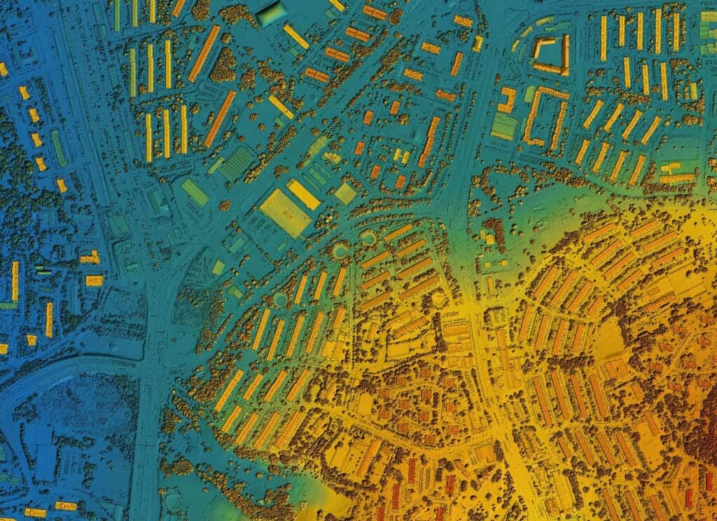
An example of an aerial LiDAR scan of a built-up urban area.
Advantages of Using LiDAR
– High Precision: LiDAR provides high-resolution data with centimeter-level accuracy.
– Speed: LiDAR systems can survey large areas quickly, significantly reducing fieldwork time.
– Versatility: LiDAR can be used in various environments, including forests, urban areas, and underwater.
Photogrammetry is the art and science of making measurements from photographs. It involves capturing multiple overlapping images of an area and using software to create 3D models and maps.
Basics of Photogrammetry: How It Works
Photogrammetry uses images captured from different angles to triangulate the position of points in 3D space. By stitching these images together, it creates detailed and accurate 3D models of the surveyed area. Photogrammetry has been around in various different forms since at least the 15th century, but it wasn’t until the 1st World War, when aerial photogrammetry really came into its own.
Applications of Photogrammetry in Surveying
– Construction: Photogrammetry is used to monitor construction progress and ensure accuracy in building projects. More and more, photogrammetry is used to precisely monitor volumes, as it is faster, and reduces risk to operators who no longer have to ascend piles.
– Archaeology: It helps in documenting and preserving archaeological sites by creating detailed 3D models.
– Agriculture: Photogrammetry is used for crop monitoring and precision agriculture, helping farmers optimize yields.
Advantages of Using Photogrammetry
– Cost-Effective: Photogrammetry is often more affordable than other surveying methods, especially for large areas. Often times, a small consumer level drone can be adapted to perform photogrammetry.
– Detailed Imagery: It provides high-resolution imagery that can be used for detailed analysis and planning.
– Accessibility: With the advent of drones, photogrammetry has become more accessible and easier to implement in various fields.
The integration of GPS with LiDAR and photogrammetry represents a significant leap forward in surveying technology. By combining these technologies, surveyors can leverage the strengths of each method to achieve unprecedented accuracy and efficiency.
How These Technologies Complement Each Other
– GPS: provides precise location data, ensuring that the spatial information collected by LiDAR and photogrammetry is accurately georeferenced.
– LiDAR: captures detailed 3D spatial data, which can be enhanced by the high-resolution imagery provided by photogrammetry.
– Photogrammetry: adds texture and colour to the 3D models created by LiDAR, providing a more comprehensive and visually appealing representation of the surveyed area.
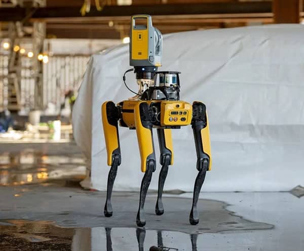
An example where this sensor fusion is employed. A Boston Dynamics robot is used to carry a robotic total station, LiDAR sensor, and GNSS receiver.
Example Projects with Successful Deployment
– Infrastructure Projects: Integration of these technologies has been successfully used in large infrastructure projects, such as highway construction and bridge inspections, where accurate and detailed surveys are critical.
– Environmental Monitoring: Combined GPS, LiDAR, and photogrammetry have been used in environmental monitoring projects to map changes in landscapes and track the impact of natural disasters.
– Urban Planning: City planners use integrated surveys to create detailed urban models that aid in planning and development efforts.
Technological Advancements Enabling Integration
Advancements in hardware and software have played a crucial role in enabling the seamless integration of GPS, LiDAR, and photogrammetry. Modern survey equipment now comes with built-in support for multiple sensors, and sophisticated software solutions are available to process and merge data from different sources.
The integration of GPS, LiDAR, and photogrammetry offers numerous benefits that are transforming the surveying industry.
Improved Accuracy and Precision in Data Collection
By combining the strengths of each technology, surveyors can achieve higher accuracy and precision in their data collection efforts. GPS provides reliable georeferencing, LiDAR captures detailed 3D spatial data, and photogrammetry adds high-resolution imagery, resulting in comprehensive and accurate surveys.
Enhanced Efficiency and Speed of Surveying Projects
The integration of these technologies significantly reduces the time required for fieldwork and data processing. LiDAR and photogrammetry can capture large areas quickly, while GPS ensures that the data is accurately georeferenced. This combination allows surveyors to complete projects more efficiently and deliver results faster.
Broader Application Possibilities Across Different Industries
The versatility of integrated GPS, LiDAR, and photogrammetry opens up new possibilities for surveying in various industries. From construction and urban planning to agriculture and environmental monitoring, these technologies provide valuable insights and data that can be used for a wide range of applications.
A drone is being readied for flight to measure the progress of a grading project in a new sub-division.
While the integration of GPS, LiDAR, and photogrammetry offers many benefits, there are also challenges and considerations that need to be addressed.
Technical Challenges in Integrating These Technologies
– Data Compatibility: Ensuring that data from different sensors is compatible and can be seamlessly integrated is a significant technical challenge. Make sure you discuss your needs with your equipment supplier and check and make sure no additional cables or software is required.
– Processing Power: The large volumes of data generated by LiDAR and photogrammetry require powerful processing capabilities and sophisticated software solutions. Data storage alone can be a significant cost, as a single project may generate TBs or data.
– Signal Interference: GPS signals can be affected by interference, which can impact the accuracy of the integrated data. This may require the integration of units like INS sensors to help mitigate signal loss.
Cost Considerations and Return on Investment
The initial investment in integrated surveying equipment can be significant. However, the long-term benefits, such as improved accuracy, efficiency, and broader application possibilities, often outweigh the costs. It is essential for organizations to carefully evaluate the return on investment when considering the adoption of these technologies.
Training and Expertise Required for Effective Use
Effective use of integrated GPS, LiDAR, and photogrammetry requires specialized training and expertise. Surveyors need to be proficient in operating advanced equipment and software, as well as in processing and interpreting the data collected. Investing in training and education is crucial for maximizing the benefits of these technologies.
The future of GPS surveying lies in the continued integration and advancement of GPS, LiDAR, and photogrammetry technologies. Emerging trends and innovations are set to further transform the industry.
Emerging Technologies and Their Impact on GPS Surveying
– 5G Connectivity: The rollout of 5G networks will enhance real-time data transmission and processing capabilities, improving the efficiency and accuracy of integrated surveys.
– Drones and UAVs: The use of drones and unmanned aerial vehicles (UAVs) equipped with GPS, LiDAR, and photogrammetry sensors will become more prevalent, enabling faster and more flexible data collection.
– Augmented Reality (AR): AR technology can provide surveyors with real-time visualizations of integrated data, enhancing their ability to make informed decisions on-site.
Geographic Information Systems (GIS) are increasingly being integrated with modern surveying technologies to enhance how spatial data is analyzed and managed. By combining GNSS data, LiDAR scans, and photogrammetry outputs within GIS platforms, surveyors can create comprehensive spatial datasets that support mapping, infrastructure planning, environmental analysis, and asset management. This integration allows professionals to visualize patterns, monitor changes over time, and make more informed decisions based on layered geographic data.
3D laser scanning and reality capture technologies are becoming essential tools in advanced surveying workflows. These systems rapidly capture highly detailed digital representations of real-world environments, producing accurate point clouds and digital twins of structures, landscapes, and infrastructure.
When combined with GNSS positioning, surveyors can georeference these models with high precision, enabling more accurate planning, inspection, and documentation. Reality capture is particularly valuable for complex environments such as industrial facilities, construction sites, and historic structures where traditional surveying methods may be slower or less detailed.
Predictions for the Next Decade in Surveying Technology
– Increased Automation: Automation of data collection and processing workflows will become more common, reducing the need for manual intervention and increasing efficiency.
– AI and Machine Learning: Artificial intelligence and machine learning algorithms will be used to analyze large datasets, identify patterns, and provide actionable insights, further enhancing the capabilities of integrated surveys.
– Enhanced Accuracy and Precision: Continued advancements in sensor technology and data processing algorithms will result in even higher levels of accuracy and precision in integrated surveys.
The integration of GPS with LiDAR and photogrammetry is shaping the future of land surveying. By combining the strengths of each technology, surveyors can achieve unprecedented levels of accuracy, efficiency, and versatility in their projects. While there are challenges to overcome, the benefits of integrated surveying far outweigh the drawbacks. As technology continues to advance, we can expect even more innovative solutions and applications in the field of surveying, making it an exciting time for the industry. Investing in integrated GPS, LiDAR, and photogrammetry technology today will ensure that organizations are well-positioned to take advantage of these advancements and remain competitive in the future.
The surveying industry is being revolutionized by advancements in GNSS (Global Navigation Satellite System) technology, and its integration with LiDAR (Light Detection and Ranging) and photogrammetry. These technologies enhance the accuracy, efficiency, and scope of surveying projects.
LiDAR technology works by emitting laser pulses and measuring the time it takes for them to return after hitting an object. This data is used to create detailed, accurate 3D maps and models of the surveyed area. LiDAR is particularly useful for capturing the topography of the land and identifying surface features.
Photogrammetry involves taking photographs from various angles and using software to stitch these images together to create 3D models or maps. This technique is essential for capturing detailed visual information about the surveyed area and is often used in conjunction with LiDAR data to enhance overall accuracy.
Integrating GPS with LiDAR and photogrammetry offers numerous benefits, including increased accuracy, improved efficiency, and the ability to capture comprehensive data sets. This integration allows surveyors to create more precise maps and models, streamline their workflows, and handle larger, more complex projects.
Challenges include the high cost of equipment, the need for specialized training, and potential data processing and management issues. Considerations also involve ensuring compatibility between different technologies and addressing any environmental factors that might affect data collection, such as weather conditions and terrain.
Bench Mark Equipment & Supplies is your team to trust with all your surveying equipment. We have been providing high-quality surveying equipment to land surveyors, engineers, construction, airborne and resource professionals since 2002. This helps establish ourselves as the go-to team in Calgary, Canada, and the USA. Plus, we provide a wide selection of equipment, including global navigation satellite systems, RTK GPS equipment, GNSS receivers, and more. We strive to provide the highest level of customer care and service for everyone. To speak to one of our team today, call us at 403-286-0333 or email us at [email protected].
